Zmanim Map 3.5 adds Date and Algorithm Selection

Vintage Map with CompassThe Zmanim Map was recently updated to version 3.5. This new release adds a number of new features (listed below), and some technical changes over the previous Zmanim Map 3.0 release. With this release, the main focus of the map has shifted to the zmanim tabs. The direction to Yerushalayim tab with davening directions using both the rhumb line and great circle route to Yerushalayim is still present, but is no longer the default tab.
Zmanim Map v3.5

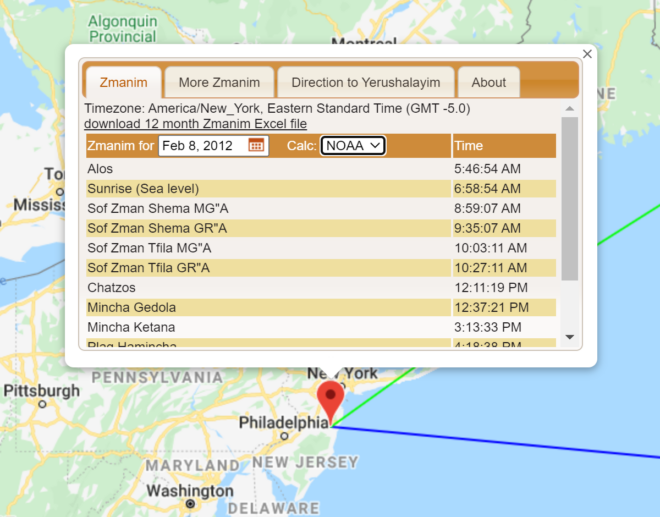
  • The date can now be selected by the user. In previous versions the date was always the current date on the user’s computer (though the map always supported passing the date on the URL using the undocumented date=1969-02-08 parameter). The current date is still the default, but the user can now change the date.
  • The calculation algorithm is now selectable. The Zmanim API supports both the USNO and NOAA algorithms. The map has always used the USNO algorithm, and this remains the default, but users can now use the NOAA algorithm.
  • The Zmanim tab is now the default tab. This reflects user feedback indicating that most people use the map for zmanim.
  • An About tab now provides a mini user guide and general information about the map.
  • The timezone look-up now uses the Google Time Zone API. Previously the map had been using the Geo Names web service. Since the elevation service also uses Google, the change to a single stable source will hopefully result in fewer outages.
  • The currently selected tab persists across location changes, so if you were viewing zmanim for a location, and changed the location to see how the zmanim were affected, you will no longer have to change tabs after each move.
  • Candle Lighting was added for Fridays. Erev Yom Tov will not show candle lighting at this point.
  • Performance improvements, minor enhancements, bug fixes and refactoring

FAQ: How Much Earlier is Sunrise on Mount Everest Due to Elevation?

Sunrise over Everest

Question:

How Much Earlier is Sunrise on Mount Everest Due to Elevation?

Answer:

The greatest sunrise and sunset elevation effect on Earth is on Mount Everest (at 27.988° N, 86.925° E as seen on the Direction to Yerushalayim Map). With an elevation of 8,848 Meters (29, 029 feet), sunrise would be up to 15 minutes and 31 seconds earlier on Mount Everest than at sea level. The range of the effect is from 15 minutes and 31 seconds on June 22nd, to a “low” of 13 minutes 41 seconds earlier on March 18th. Being in a large mountain range with obstructed horizons, it is likely never actually seen that early. In addition to questions about mountains, every few months I get asked about how much earlier sunrise/set can be seen in skyscrapers. There are various halacha questions as to whether this actually affects zmanim that I will mention later. Here are some raw numbers. Burj KhalifaBurj Khalifa (at 25.197° N, 55.274° E as seen on the Direction to Yerushalayim Map) is the tallest building in the world. With a height of 828 m (2,717 ft), visible sunrise to someone standing on top of the crown (something unrealistic) on June 22nd would be at 5:24:56 AM versus 5:29:31 AM on sea level, a difference of 4 minutes and 35 seconds. Sunset would be 7:16:35 PM versus 7:12:00 PM at sea level, a difference of 4 minutes and 35 seconds. A more realistic scenario would be the visibility sunrise on the highest floor (the 160th), an elevation of 672 m (2,204 ft) at 5:25:23 AM, a difference of 4 minutes and 8 seconds earlier than sea level. Sunset on the 160th floor would be 7:16:08 PM, or 4 minutes and 8 seconds later than at sea level.
As far as the halacha being affected by the elevation of buildings, the Baal Hatanya seems to indicate that tall buildings would make sunset later. See Yisroel vehazmanim ישראל והזמנים Vol II, page 910. In the Shraga Lachaim שרגא לחיים footnotes Rabbi Harfenes states that

ויש להוסיף שהוא דבר תמוה לומר דעד שלא נבנו הבנינים הגבוהים היה זמן שבת התלוי בשקעה”ח (שקיעה ראשונה להגאנים ושקיעה שניה לר”ת) מוקדם, ולאחר שנבנו יש לאחר הזמנים, ועד עכשיו שהיו בניו יארק הבנינים התאומויות (טווין-טאוע”ר בלע”ז) שכל א’ מהם היה בת ק”י קומות היה זמן השקיעה מאוחר, ועתה לאחר שהפילו והרסו אותם רשעים וזדים ארורים ימ”ש חזר הדבר לקדמותו להקדים זמן השקיעה.

Zmanim API 1.2 Released

The Zmanim API 1.2 was released today. The only change in this release is the removal of elevation as a factor in the calculation of all zmanim besides sunrise and sunset. Updated JavaDocs now reflect these changes. Please see the Elevation Now Only Impacts Sunrise and Sunset Calculations in the Zmanim API post for additional information.

I would like to thank the various people who contacted me on the subject.

The main download is the Zmanim 1.2 release zip file that includes source files and JavaDoc documentation. Also available for download (included in the above zip file) is the main zmanim-1.2.jar. The zmanimAstronomical-1.1.jar that only includes the AstronomicalCalendar was not impacted by this change, but the version has been updated to zmanimAstronomical-1.2.jar for consistency. Additional detail on the downloads can be seen on the Zmanim Download page

Elevation Now Only Impacts Sunrise and Sunset Calculations in the Zmanim API

Sunrise over Everest

Note: On Aug 1, 2018 – כ״א אב תשע״ח, elevation became optionally available as a factor in most zmanim calculations. The KosherJava Zmanim library was updated to optionally allow using elevation as an attribute that will adjust most zmanim via the ZmanimCalendar​.setUseElevation(boolean). There are some zmanim such as degree-based zmanim that are driven by the amount of light in the sky and are not impacted by elevation. These zmanim intentionally do not support elevation adjustment. The following is the original post.


I have received a few emails over the past year or so about the use of elevation as part of the calculation of various zmanim in the API. All releases of the zmanim API up to the current 1.1 release, use elevation to affect the calculation of all sunrise/sunset based zmanim. While my footnote on the Zmanim Calendar Generator page stated that this only impacted sunrise and sunset (quoting the Yisrael Vehazmanim and Calendrical Calculations), in practice all zmanim calculated based on sunrise and sunset were affected by elevation. An example of a zman that used elevation in 1.1, but will no longer in 1.2, is the calculation of Sof Zman Krias Shema according to the GR”A. The soon to be released version 1.2 limits the impact of elevation to sunrise and sunset only. The Zmanim Calendar Generator page already uses the latest changes to the code. To facilitate changes by ports of the API, a list of changes to the source code of the ZmanimCalendar.java and ComplexZmanimCalendar.java is available in a diff file (a proper Unix diff/patch is not available at this time). The diff files were generated prior to updating the JavaDocs to simplify the work of anyone modifying ports of the Zmanim API. Detailed sources for not using elevation for anything besides sunrise and sunset can be found in פרק ב׳ סעיף ט׳ (pages 186-187) in the second edition of Zmanim Kehilchasam זמנים כהלכתם by Rabbi Dovid Yehuda Bursztyn.

Elevation Lookup Added to Zmanim Calendar Generator

Sunrise CalendarA lookup tool for elevation lookup was added to the Zmanim Calendar Generator page. This service is courtesy of Jonathan Stott’s earthtools.org elevation webservice. This Elevation data currently only covers all of mainland Europe (between latitudes 35°N and 60°N and longitudes 35°E and 15°W) and all of the contiguous states of the United States of America (between latitudes 20°N and 50°N and longitudes 65°W and 125°W). The source of the data is:

The terrain model used to find heights above sealevel is from the Shuttle Radar Topography Mission (SRTM) which was a joint project between the US National Geospatial-Intelligence Agency (NGA) and the National Aeronautics and Space Administration (NASA). Data was recorded for 11 days from the Space Shuttle Endevour from 11th February 2000. The data used here is at a resolution of 3 arc seconds (approximately 90m).

The lookup is done via an AJAX call.